
 FORT CLATSOP...LEWIS AND CLARK PARTY 1805 WINTER HOME. 28 ENLISTED MEN, TWO OFFICERS, A BLACK "SLAVE" OF CAPTAIN LEWIS AND SACAJEWEA, HER SON AND HUSBAND, A FUR TRADER.
 OREGON CASCADE MOUNTAINS LOOKING EAST FROM US 101 SOUTH OF ASTORIA, OREGON
 ASTORIA - FROM US 101 SOUTH OF ASTORIA
 LOUISIANA PURCHASE AND OREGON TERRITORIES
 FORT CLATSOP SOUTH GATE. ENLISTED QUARTERS (3 ROOMS) ARE ON THE LEFT...SUPPLY ROOM, ORDERLY ROOM, OFFICER QUARTERS, AND SACAJWEA QUARTERS ARE ON RIGHT . THIS IS A RECONSTRUCTION FROM THE ORIGINAL PLANS...SET WITHIN A COUPLE FEET OF THE ORIGINAL.
FORT CLATSOP COURTYARD

ENLISTED QUARTERS...8 MEN PER ROOM X 3 ROOMS = 28 MEN (SOLDIERS)
 STORE ROOM
 SACAJEWEA'S ROOM
 FORT CLATSOP LAYOUT
 ALPACA CHARACTERISTICS
 BRUCE AT PEGGY'S ALPACA RANCH
 ALPACAS WANT TO BE IN THE ACTION
 ALPACAS ARE STATELY
 ALPACAS HAVE SOFT LIPS AND THEY LOVE TO NIBBLE...BUT HAVE ONLY LOWER FRONT TEETH AND RARELY NIP. ALPACAS MAKE EXCELLENT PETS AND ARE VERY INTELLIGENT.
 ALPACAS ARE VERY SOCIAL ANIMALS...WHEN PISSED OFF, THEY CAN AND DO "SPIT" QUITE LONG DISTANCES...USUALLY AT ANOTHER ALPACA...BUT NOT ALWAYS
 PEGGY'S ALPACA RANCH - FROM THE FIELDS...SORRY I HAVE NO PIC FROM THE HOUSE...IS REALLY MAJESTIC.
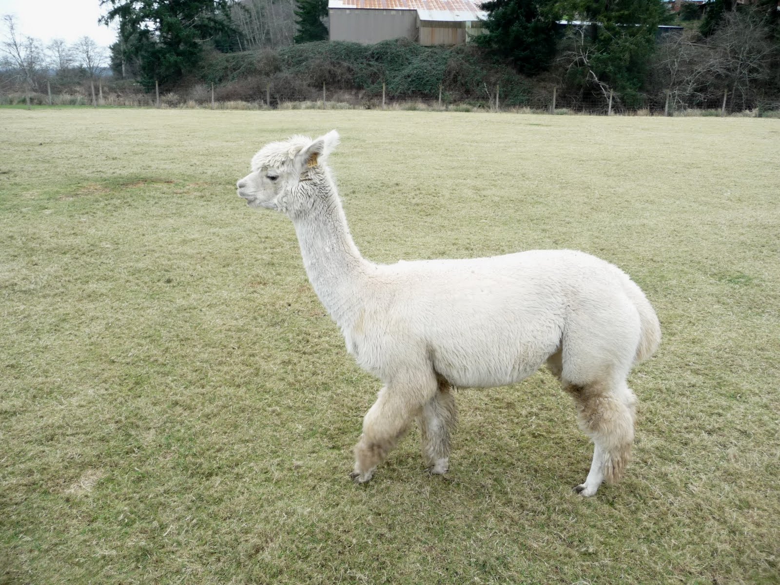 ALPACA GESTATION IS 11 MONTHS...BEST TIME TO BREED IS WITHIN 27 DAYS AFTER DELIVERY...NON-PREGNANT GIRLS HANG CLOSE TO PREGNANT GIRLS...AS PEGGY SAYS...SAYING "ME NEXT" "ME NEXT "ME NEXT"...SEEMS THEY LIKE BEING PREGNANT. UPON BEING BORN, THE NEWBORN IS UP ON ITS FEET WITHIN MINUTES AND ROMPING AROUND A FEW MINUTES LATER.
 BOYS AND GIRLS ARE KEPT SEPARATE. ALPACAS CAN HAVE NO MENSTRAL CYCLE AND CAN BECOME PREGNANT AT ANY TIME.
 A PRIMARY GOAL OF PEGGY'S RANCH IS BREEDING FOR IMPROVED CHARACTERISTICS...COLOR IS NOT ONE OF THEM...THE COLOR YOU GET IS THE COLOR YOU GET.
What a delightful afternoon at Peggy's Alpaca Ranch.
DAY 21 – ASTORIA, OREGON
SPIA spent a comfy night in the parking lot of LUM’s TOYOTA, surrounded by shiny new cars.
Well before daylight…at 4am actually, I was up and spent the next 2.5 hours – with SPIA’s motor running to generate electricity, completing our blog…Verizon kept dropping out their signal all night long.
At 7am, started our walk to Astoria, some 6 miles back up US 101. Traffic is quite heavy on US 101, but the roadway is well engineered with plenty of “bicycle” Berm. On the way back to SPIA, stopped for breakfast at a small place at the end of the Causeway…very good with plenty of conversation.
Arriving back at SPIA, thanked the LUM folks and chatted with the mechanic who worked on SPIA. She had her electrical harness (plugs, wires, distributor cap & rotor) and a couple other things tweaked. She now purrrrs like a wee kitten.
Then, we drove out to FORT CLATSOP – the Lewis and Clark 1805 Winter Home…see pics. Again got that spine tingle walking around in History’s footsteps…Sacajawea actually lived in this room…Captain Clark actually drew his famous maps on this table…
Was particularly surprised to learn ho3w really large the Louisiana Purchase was…it extended from (present day New Orleans) the Mississippi Delta all the way up the Mississippi and Missouri River Watershed, which reached from the Great Lakes to the East into the Rocky Mountains in the West…and well into what is now Canada.
The Lewis and Clark exploration started out as a big secret because it was actually Spanish and French territory they would be exploring…until France assumed ownership of the entire geographic area and the United States in 1803 purchased the whole enchilada from France (Napoleon Bonaparte)…so the need for secrecy was now gone…Lewis and Clark were exploring United States Territory…at least until reaching the Far West into what in 1845 became the Oregon Territory…which extended from about the present California Northern Border clear into Central Alaska…including much of present day British Columbia
I thought I walked much of the Lewis and Clark Expedition Route last Summer on my walk to Oklahoma City…I WAS WRONG. I only walked that portion of the Columbia River from present day Longview, Washington, to Mount Hood, Oregon…Lewis and Clark took the Northern route – close to present day US 20, whereas I took the more Southern Route – on present day US 30…the Oregon Trail over the Rocky Mountains and the Great Plains.
Leaving FORT CLATSOP, we drove to Peggy’s Ranch “TUCKER CREEK ALPACAS”.
What a surprise…Peggy runs the ranch while Husband Dave is holding down the fort in their SAN DIEGO, CALIFORNIA home.
With a beautiful home built on the hillside on the North of the Ranch acres spread out in a "radial" pattern filling the Front Room Window, a large herd…or rather a number of “divided” groups of these gorgeous animals moved quickly to the “spot of interest” along individual pasture fence lines…curious to know AND BECOME A PART of any excitement.
Received the Grand Tour, walking with Peggy from the ultra modern barn to one pasture of all the “Guys”, into another pasture of the “unusual” Gals, into another pasture yet, with all he recent “Moms”, a few offspring…and one Eunuch…who found he liked girls only after he was “altered”…so he is allowed the pleasure of female companionship while his peers watch greedily from two pastures over.
Apologize I cannot recall most of the terms Peggy used to describe attributes and functions of her babies – each of which (over 80 critters all told) has a personal name and all seem to adore Peggy.
Most were a bit unsure about ME. A few came right up, nibbled my fingers and sniffed around…but everybody (and I use the term “everybody” intentionally) wanted to get close and check out this new visitor. They are used to many visitors, as everyone I spoke to on both the Washington and Oregon side of the Columbia River knew or knew of Peggy and his children…and knew exactly where they lived.
Met Fran.
Fran, Peggy's Mom, is 90 years old this year and simply cannot believe it. We had a few hours, Fran and I to chitchat about the “First Depression” (her term) and some events we shared living on farms during that difficult time…and how it differs from today…especially from the standpoint of opportunities and responsibilities of “youngsters”…i.e.; if we wanted to eat, we worked…and we both LOVED our youngster working days.
Susan, friend, client, and OR Physician Assistant – who recently bought her own Alpaca from Peggy – visited while I was there. As Susan lives in town in an apartment, her “child” is boarded by Peggy, giving Susan unlimited “visiting rights”.
Also met Russ, the Vet, who checked out one of the Alpacas…
So much more…could write a book about this one afternoon…Peggy says…Bruce…why don’t ;you write a book…I had / have no reply.
Shared a large family-size Pizza with everyone – and took home a doggie bag which included a few of Fran’s Zucchini Muffins.
Reluctant to leave…Peggy offered SPIA to park overnight – we followed Susan back to SEASIDE, OREGON, where SPIA is just below the window of her second-floor apartment.
DAILY REPORT: Walked 10 miles – count 5 miles
SEE YOUR IMPACT.ORG: Credit 5 miles @ $0.02 = $0.10 for the day
It is noW 1:00am in the morning. Verizon was erratic again last evening, so gave it up until waking at Midnight with the day’s conversations rolling around in my head…so, got up, made two Tuna Salad Sandwiches – long ago consumed – and finished this narrative.
In the morning, will walk back to LUM’s and return…then head South on US 101 into the next episode of SAM & ME AND SPIA.
Getting sleepy - hope it is not SPIA's motor exhaust -, so, will upload the pics in a few hours...now back to the feathers.
DAY 21 – ASTORIA, OREGON
SPIA spent a comfy night in the parking lot of LUM’s TOYOTA, surrounded by shiny new cars.
Well before daylight…at 4am actually, I was up and spent the next 2.5 hours – with SPIA’s motor running to generate electricity, completing our blog…Verizon kept dropping out their signal all night long.
At 7am, started our walk to Astoria, some 6 miles back up US 101. Traffic is quite heavy on US 101, but the roadway is well engineered with plenty of “bicycle” Berm. On the way back to SPIA, stopped for breakfast at a small place at the end of the Causeway…very good with plenty of conversation.
Arriving back at SPIA, thanked the LUM folks and chatted with the mechanic who worked on SPIA. She had her electrical harness (plugs, wires, distributor cap & rotor) and a couple other things tweaked. She now purrrrs like a wee kitten.
Then, we drove out to FORT CLATSOP – the Lewis and Clark 1805 Winter Home…see pics. Again got that spine tingle walking around in History’s footsteps…Sacajawea actually lived in this room…Captain Clark actually drew his famous maps on this table…
Was particularly surprised to learn ho3w really large the Louisiana Purchase was…it extended from (present day New Orleans) the Mississippi Delta all the way up the Mississippi and Missouri River Watershed, which reached from the Great Lakes to the East into the Rocky Mountains in the West…and well into what is now Canada.
The Lewis and Clark exploration started out as a big secret because it was actually Spanish and French territory they would be exploring…until France assumed ownership of the entire geographic area and the United States in 1803 purchased the whole enchilada from France (Napoleon Bonaparte)…so the need for secrecy was now gone…Lewis and Clark were exploring United States Territory…at least until reaching the Far West into what in 1845 became the Oregon Territory…which extended from about the present California Northern Border clear into Central Alaska…including much of present day British Columbia
I thought I walked much of the Lewis and Clark Expedition Route last Summer on my walk to Oklahoma City…I WAS WRONG. I only walked that portion of the Columbia River from present day Longview, Washington, to Mount Hood, Oregon…Lewis and Clark took the Northern route – close to present day US 20, whereas I took the more Southern Route – on present day US 30…the Oregon Trail over the Rocky Mountains and the Great Plains.
Leaving FORT CLATSOP, we drove to Peggy’s Ranch “TUCKER CREEK ALPACAS”.
What a surprise…Peggy runs the ranch while Husband Dave is holding down the fort in their SAN DIEGO, CALIFORNIA home.
With a beautiful home built on the hillside on the North of the Ranch acres spread out in a "radial" pattern filling the Front Room Window, a large herd…or rather a number of “divided” groups of these gorgeous animals moved quickly to the “spot of interest” along individual pasture fence lines…curious to know AND BECOME A PART of any excitement.
Received the Grand Tour, walking with Peggy from the ultra modern barn to one pasture of all the “Guys”, into another pasture of the “unusual” Gals, into another pasture yet, with all he recent “Moms”, a few offspring…and one Eunuch…who found he liked girls only after he was “altered”…so he is allowed the pleasure of female companionship while his peers watch greedily from two pastures over.
Apologize I cannot recall most of the terms Peggy used to describe attributes and functions of her babies – each of which (over 80 critters all told) has a personal name and all seem to adore Peggy.
Most were a bit unsure about ME. A few came right up, nibbled my fingers and sniffed around…but everybody (and I use the term “everybody” intentionally) wanted to get close and check out this new visitor. They are used to many visitors, as everyone I spoke to on both the Washington and Oregon side of the Columbia River knew or knew of Peggy and his children…and knew exactly where they lived.
Met Fran.
Fran, Peggy's Mom, is 90 years old this year and simply cannot believe it. We had a few hours, Fran and I to chitchat about the “First Depression” (her term) and some events we shared living on farms during that difficult time…and how it differs from today…especially from the standpoint of opportunities and responsibilities of “youngsters”…i.e.; if we wanted to eat, we worked…and we both LOVED our youngster working days.
Susan, friend, client, and OR Physician Assistant – who recently bought her own Alpaca from Peggy – visited while I was there. As Susan lives in town in an apartment, her “child” is boarded by Peggy, giving Susan unlimited “visiting rights”.
Also met Russ, the Vet, who checked out one of the Alpacas…
So much more…could write a book about this one afternoon…Peggy says…Bruce…why don’t ;you write a book…I had / have no reply.
Shared a large family-size Pizza with everyone – and took home a doggie bag which included a few of Fran’s Zucchini Muffins.
Reluctant to leave…Peggy offered SPIA to park overnight – we followed Susan back to SEASIDE, OREGON, where SPIA is just below the window of her second-floor apartment.
DAILY REPORT: Walked 10 miles – count 5 miles
SEE YOUR IMPACT.ORG: Credit 5 miles @ $0.02 = $0.10 for the day
It is noW 1:00am in the morning. Verizon was erratic again last evening, so gave it up until waking at Midnight with the day’s conversations rolling around in my head…so, got up, made two Tuna Salad Sandwiches – long ago consumed – and finished this narrative.
In the morning, will walk back to LUM’s and return…then head South on US 101 into the next episode of SAM & ME AND SPIA.
Getting sleepy - hope it is not SPIA's motor exhaust -, so, will upload the pics in a few hours...now back to the feathers.


