Sunday, December 6, 2015
POST 1489; CORPUS CHRISTI, TX.; 12-06-15
As hoped, walked the town and waterfront of Fort Lavaca this morning, taking a few photographs posted below.
Since is Sunday, visited a local Southern Baptist, which was well attended. The Service was well planned backed by video. A number of the Congregation participated resulting in an interesting and informative sermon.
See next photograph for an explanation of the above Civil War Scene.
Boat Launch Facilities.
Being directly on the Gulf Of Mexico, boating is nearby and year-round.
Fort Lavaca Main Street.
Most businesses are closed - Out Of Business ... the buildings have fallen into disrepair.
Town Theatre ... now serving as a Church.
Another converted Retail Shop housing the Southern Baptist Church I attended this morning.
Grabbed a bite of lunch after Church; then drove to the City of Corpus Christi where we are once again in the Parking Lot of WALLMART.
Errant shot while driving in traffic.
U S of A and TEXAS State Flags flying side by side.
* * * * * * * * * *
Tomorrow we continue toward the City of BROWNSVILLE. There are many small towns near Brownsville, so plan to do some walking and blogging before turning North toward EL PASO, Texas.
Saturday, December 5, 2015
POST 1488; PORT LAVACA, TX; 12-05-15
Intended to do some walking today.
It did not happen.
Instead, we spent 8 hours trying to find our way among the Coastal Roadways skirting trhe Gulf Coast between the town of ORANGE and PORT LAVACA, Texas.
We have the most recent road map from WALLMART, but with many new roadways , the Map is not much help. Must have asked directions fifteen times.
Eventually, we have arrived at the town of Port Lavaca, about half way to the City of BROWNSVILLE, Texas, located on the border with Mexico.
The Gulf Coast driven today can be divided into TWO distinct regions:
1. Swampy Empty expanses with many small villages on the waters edge from ORANGE to the City of GALVESTON. These homes are on stilts with NO protection from the Sea.
2. Heavy industrial centers - primarily OIL REFINERIES -. and lush pastures complete with grazing cattle. Must say, however, the beef look a bit skinny ... more like Dairy Cows.
State of TEXAS DOT furnishes FREE modern Ferry Boats to cross Galveston Harbor for Route 73, the coastal highway at that location.
We are driving onto the ferry boat in the above photograph.
CORMORANT and PELLICAN resting on the Ferry Dock Guide Posts (PYLONS) which help ferry boats maneuver into their SLIPS.
We are first in line on the Ferry Boat crossing to the City of GALVESTON.
The funny looking boat in the distance (with three vertical posts) is the twin of our Ferry Boat.
A Gas Barge being PUSHED across Galveston Harbor.
A Freighter / Container Ship mounting a large Luffing - Rotating CRANE ... to ON and OFF Load freight at remote Islands and small Ports with limited Dock Side Facilities. For many years I worked as Contracts Manager for Lockheed Aircraft Crane Division AND Germany's KRUPP manufacturing similar cranes as on this ship.
High Tech Design Pylons at Galveston Ferry Dock. To drive the boat into it's "Slip", these pylons guide the Ferry Boat precisely under the CENTER of the loading RAMP, over which vehicles drive ON and OFF the boat.
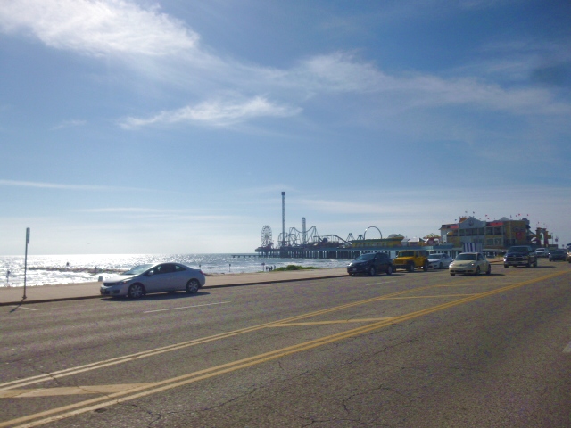
Galveston waterfront is a long stretch of wide Boulevards, Sandy wave swept beach, and endless Shops. Even today, so close to the Holidays, promenading sun worshipers are out and about. No one in the water, though.
A downtown Pier of "RIDES" and entertainment.
If I had a bit more $$, would like to spend a couple days in Galveston.
Bicycles FOR RENT.
Galveston Harbor LIGHT HOUSE.
Small piece of Galveston's miles - long Beach.
Yes, that IS the Gulf Of MEXICO ... one of those memorable romantic places I ask for a lovely "partner" to be by my side ... to hold my hand ... to whisper ... "...and it so beautiful".
Such a sight I consider my own private ASSET; and as many already know, an ASSET has VALUE only when it is shared.
A small "Stilt" home ocean - side village.
Homes are also found nestled in shore-side seclusion.
... and another such abode.
One of the many Oil / Gas Refineries found West of Galveston.
... and another one.
Crossing one of the many impressive bridges linking Route 73 from shore to shore over the many Bays along TEXAS Gulf Coast.
Thankfully, not much traffic today.
...down side of the same bridge.
A "foundation" (looking like so many TOOTH PICKS a scant few feet from the waters of the Gulf Coast) ... soon to bear a new home just like the one - and hundreds of unseen ones - in the distance.
Route 93 skirting TEXAS' Gulf Coast.
* * * * * * * * * *
I am POOPED OUT this evening.
We have refuge for the night in Fort LAVACA WALLMART Parking LOT.
Really, we Travelers owe a great debt to WALLMART, who provides FREE overnight parking AND security 24 / 7 at hundreds of locations across the US of A.
I know not if I will walk tomorrow. I hope so ... and plan to walk. Perhaps we can find an interesting spot ... perhaps right here in Fort Lavaca ... to walk the city up close and personal.
We shall see !
Friday, December 4, 2015
POST 1487; ORANGE, TEXAS; 12-04-15
At first light this morning, tried to drive US 90. It turned out to be impossible. After searching searching searching, found it. Maps are of little use as US 90 is often incorporated into I-10 ... then simply disappears; only to resurface again some many miles further West. This is because of new road construction projects.
Mostly, drove I-10 to the TEXAS border until US 90 appeared. Drove US 90 to the village of Orange, Texas where we stopped at DENNY's Restaurant and FLYING "J" Truck Stop, gathering VERY few pictures for today's Blog.
I-10 West of New Orleans travels 100 Plus miles on concrete CAUSEWAYS over endless SWAMPS. One stretch over swamps is 18 miles long with NO side roads.
The above roadway is elevated about 20 feet in the air over continuous swamp waters...not all that scenic.
Looking at a map of the area, one finds South of I-10 endless swamp with not a single alternate road in sight. US 90 would normally be in such a place, but there is NO place to put it.
So, much of I-10 is also called US 90.
More of I-10 on the Causeway.
...and more of the same; I-10 Causeway.
Finally reaching US 90 in TEXAS, came upon this miniture WALLMART standing alone in farming country miles from the nearest tiny village. I stopped, filled up with GAS ($1.77 per gallon), and went inside to find Wall-To-Wall FOOD . nothing but things to eat !
In the entire US of A, never before encountered such a thing !
TEXAS, too, is empty SWAMP with few roadways.
I-10 Bridge spanning one of the few ivers emptying out of the endless swamp into the Gulf of Mexico.
We plan to follow which ever roadway is available (near the actual Gulf from Orange - where we now are and will spend the night - Flying "J" Truck Stop) all the way to the City of BROWNSVILLE. From Brownsville, we will walk and roll North near the Rio Grande River, following the MEXICO border to EL PASO, where we will take secondary roads adjacent to I-10 thru New Mexico, Arizona, and then, California to the City of BAKERSFIELD.
We have walked little so far. With TEXAS in front of us ... and having more secondary roads instead of Interstate highways, we plan to walk much of the rest of this journey.
* * * * * * * * * *
A comment about I-10 and Old South roadways in general ...:
This is our third walk and roll through this, the Gulf Coast. Most of this region ... in fact much of the entire South East ... is essentially SAND of some sort. Many secondary roadways are pre-Civil War vintage; i.e., a solid surfaced roadway built on unstable sand soil. The roadways are for the most part, NARROW, THIN ROADWAY SURFACE, and mostly non existent BERMS (bicycle / walking space on the side of the pavement).
Walking must therefore be done on the PAVED surface - where the automobiles drive.
Bridges down here are without ANY space outside the White Painted Line marking the edge of the already NARROW paved surfaces.
Exciting is a insufficient FORE-WORD. I have often JUMPED off non-existing BERMS, and at least three times, climbed steel bridgework - leaning out over the waters below to avoid oncoming 18-wheelers from sweeping me into oblivion (for there is NO room for me AND an 18-Wheeler to cross a bridge together.
As far as I-10 is concerned...: Shame on the designers / builders. The SUB-BASE is totally inadequate to carry the concrete slabs which form the driving surface. The SAND has subsided between slabs, causing adjacent slabs of roadway to fall away from each other, forming a DITCH between slabs. Vehicles receive a JARRING JOLT as they roll over the ditches. Passengers and vehicles are very shaken after a short distance traveling I-10. (Solution: Design a proper SUB-Base to stabilize the roadway to prevent fluid sand from moving. Vehicle weight and vibration of passing vehicles is not the only consideration. Mother Nature inputs heat, cold, and rain which also destabilizes the fluid-like sand.
Thursday, December 3, 2015
POST 1486; LA PLACE, LA.;12-03-15
Back on the road once again. We shared the home of Ron and Vicki of SOSO, Mississippi for the past two days ( and nights). We are too late in the season to meet up with one of the many poison snakes which share their property, but Ron assures us he limits his excursions into the forest and grassy fields when they are out and about.
Please say HELLO to our Hosts, Ron and Vicki. Thank you ever so much. It has been good to break bread and share a couple bottles of your wonderful home - vinted wines once again. Regret I missed harvesting the Sugar Cane. Dinner, with veggies from your extensive garden was a wonderful pleasure.
Do, however apologize for the many hours bending your ears late into the evenings
Ron and Vicki's gracious home.
Front yard . until recently, a wilderness swamp.
One of Ron's three barns ... all chock full of everything a Gentleman Farmer from Mississippi could ever want.
The BUSH WHACKER Ron uses to keep the ever present swamp grasses and bushes under control.
RON and I spent a few hours on one of his new projects...this one, a fifteen foot high lofty DEER BLIND. The critters are Garden Fed, so figures this Deer Season will be pay-back time.
Ron led us this norning to I-59, which we drove to the city of GULFPORT, Mississippi.
From GULFPORT, we drove Highway 90 to New Orleans and beyond to La Place a few miles West of the city. In the morning, plan to re-acquire US 90, following that scenic Gulf Coast shoreline road to Texas and beyond.
GULFPORT pure white sand beach.
This city was, along with New Orleans, devestated by recent hurricanes. Block after city block are now without expensive homes ... washed away by the hurricane winds and floods. Estimate near HALF of remaining estate waterfront homes, as well as empty forlorn building sites have FOR SALE signs.
Above pic appears to be one of the US NAVY new class of SUPER DESTROYERS. This photograph was taken about a half mile away from US 90 on GULFPORT water front.
US 90, GULFPORT, Mississippi.
Nearly all newly built homes are perched some 20 feet in the air ... hoping waters flooding the city will simply flow under the homes instead of washing them away.
US 90 on the South East shore line of Lake Pontchartrain which was breached, flooding nearly all of the city of New Orleans.
The Mississippi River empties into the sea level estuary , building - tearing down - re building sand islands (above) which are home to all sorts of animals, fish, and birds.
Gulf shore line homes ... ALL . on stilts.
City of New Orleans as we approach from the North East on US 90.
Interstate 10 passing Lake Pontchatrain.
* * * * * * * * * *
Near this point, we entered the city of La Place. It is now 4:00 PM. Will post this up date ... then find a place to stay over night with SPIA.
Tomorrow we plan to continue on US 90 following the Gulf Coast at least to the border of the State of TEXAS.
Please say HELLO to our Hosts, Ron and Vicki. Thank you ever so much. It has been good to break bread and share a couple bottles of your wonderful home - vinted wines once again. Regret I missed harvesting the Sugar Cane. Dinner, with veggies from your extensive garden was a wonderful pleasure.
Do, however apologize for the many hours bending your ears late into the evenings
Ron and Vicki's gracious home.
Front yard . until recently, a wilderness swamp.
One of Ron's three barns ... all chock full of everything a Gentleman Farmer from Mississippi could ever want.
The BUSH WHACKER Ron uses to keep the ever present swamp grasses and bushes under control.
RON and I spent a few hours on one of his new projects...this one, a fifteen foot high lofty DEER BLIND. The critters are Garden Fed, so figures this Deer Season will be pay-back time.
Ron led us this norning to I-59, which we drove to the city of GULFPORT, Mississippi.
From GULFPORT, we drove Highway 90 to New Orleans and beyond to La Place a few miles West of the city. In the morning, plan to re-acquire US 90, following that scenic Gulf Coast shoreline road to Texas and beyond.
GULFPORT pure white sand beach.
This city was, along with New Orleans, devestated by recent hurricanes. Block after city block are now without expensive homes ... washed away by the hurricane winds and floods. Estimate near HALF of remaining estate waterfront homes, as well as empty forlorn building sites have FOR SALE signs.
Above pic appears to be one of the US NAVY new class of SUPER DESTROYERS. This photograph was taken about a half mile away from US 90 on GULFPORT water front.
US 90, GULFPORT, Mississippi.
Nearly all newly built homes are perched some 20 feet in the air ... hoping waters flooding the city will simply flow under the homes instead of washing them away.
US 90 on the South East shore line of Lake Pontchartrain which was breached, flooding nearly all of the city of New Orleans.
The Mississippi River empties into the sea level estuary , building - tearing down - re building sand islands (above) which are home to all sorts of animals, fish, and birds.
Gulf shore line homes ... ALL . on stilts.
City of New Orleans as we approach from the North East on US 90.
Interstate 10 passing Lake Pontchatrain.
* * * * * * * * * *
Near this point, we entered the city of La Place. It is now 4:00 PM. Will post this up date ... then find a place to stay over night with SPIA.
Tomorrow we plan to continue on US 90 following the Gulf Coast at least to the border of the State of TEXAS.
Subscribe to:
Posts (Atom)