
 Well, pretend this is a book and the above is the cover...Covers Sell Books.
 This is Highway 60 a bit South of the large City of MESA, ARIZONA.
 PHOENIX, ARIZONA is made up of a number of large Cities...all together, known as PHOENIX.
Dan's Home, SCOTTSDALE is one of the PHOENIX cities; so is CHANDLER, the home of nephew and Niece Dave & Melissa. MESA is one of the largest - in area - and is on the Easternmost side of PHOENIX.
Highway 60 exits out of MESA.
We walked Highway 60 South...then East over some prodigious mountains, ending up for the night in the unincorporated town of TOP OF THE WORLD, ARIZONA.
 Along the way, we say a number of new - to ME - cactus plants, like the one above.
 ...and this one...actually, a tree about 4 feet high with 3-inch long needles. They grow in large groves along Highway 60.
 A prominent landmark leaving MESA on Highway 60 is this, Superstition Mountain. Many business pick up on the name. I had a yummy lunch at a restaurant in Superstition Village.
 This is Highway 60, looking South and East. Those mountains in the distance are the Pinal Mountains, which this afternoon, we will have tons of fun trying to climb....all 7 degree of them
 One of the Pinal Mountains - at about 3,000 feet elevation ...up from the 400 or so feet of PHOENIX - fronted by a Greasewood Tree in full bloom. The desert is covered with these beautiful yellow flowers...all full of buzzing bees collecting honey.
 Many cactus are also blooming at the moment. The desert is really a sight to behold...full of colors, with yellow and purple predominate.
 An up close view of the cactus bloom in the previous photograph...just gorgeous...reminds me of a water Lilly.
 Ow, gee...here is that woman again
Please give a pleasant HELLO to Toni, a resident of the small village of SUPERIOR, ARIZONA.
Toni and I met over a beer after my third walk...an unfruitful walk up several 7 degree hills only to be turned back after 3 miles climb to a tunnel with no place for walkers.
Toni offered to drive me back up beyond the tunnel so I could continue walking up the mountain.
I had an optional idea...that we chat for a while over our drink. I won.
A recent Widow, she is looking...yes, just looking...driving could be an option
A recent Widow, she is looking...yes, just looking...driving could be an option
Now I ask you: just how am I to continue on my mission and try to feed such a woman at the same time. Kram probably has at least one suggestion !
We agreed Toni would be a "follower"...and who knows...every corner - as we now know - has it's own surprises for us.
 This is the mountain Highway 60 and Brucie Baby will climb this afternoon.
SPIA will stay parked next to Toni's place.
 Relieving myself at the "Rest Stop" next to Toni's Place, a voice from the next urinal...you working on the highway (he means ...why the yellow vest).
I go wash my hands...nope, just walking across the USA; your walking "WHERE"
Turns out Sonny is a full blooded Apache Native American Indian living on the Apache Reservation through which Highway 70 runs - which I will walk on my way to EL PASO, TEXAS.
Interspersed with various superlatives, Sonny becomes an instant "follower", hands me $2.00 "to help you on your way", and we agree to keep a sharp eye out as I walk His Reservation.
Without blushing, please give a big HELLO to Sonny...an ecologist and land developer for the Apache Indian Reservation.
Without blushing, please give a big HELLO to Sonny...an ecologist and land developer for the Apache Indian Reservation.
 The Pinal Mountains are STEEP, ROCKY, and BEAUTIFUL.
A stiff wind - forecast as up to 50 miles per hour - was blowing UP the canyons followed by Highway 60. Going up was fun...pushed all the way by the wind...coming down was not so fun...nearly got blown off the bridge...I mean it...gusts well above 50 mph hit me and nearly knocked me over the railing.
 Toni's Village, SUPERIOR, ARIZONA.
 Toni's Village, SUPERIOR, ARIZONA.
Pinal Mountains in the background. This is the beginning of the Rocky Mountains.
 Looking down on SUPERIOR, ARIZONA from the mountain pass a mile above on Hwy 60.
 Looking down on SUPERIOR, ARIZONA from the mountain pass a mile above on Hwy 60.
This view is looking to the West.
 The BRIDGE...where the wind nearly sent me plummeting with over 50 mph wind gusts.
 The Bridge, looking down from above...not too far from the Tunnel.
 The Tunnel with NO provisions for walkers. NO sidewalks. No space beyond the white line.
 The BRIDGE...where the wind nearly sent me plummeting with over 50 mph wind gusts.
 The Bridge, looking down from above...not too far from the Tunnel.
 The Tunnel with NO provisions for walkers. NO sidewalks. No space beyond the white line.
Suicidal to enter...although, I did just to make certain I could not safely walk through...I got out in a hurry after only 30 feet or so inside.
 Driving SPIA up to THE TOP OF THE WORLD.
 Driving SPIA up to THE TOP OF THE WORLD.
When arriving at the "TOP", I parked SPIA and walked back down for 1.5 hours. figure I more than covered the 8 miles from SUPERIOR to TOP OF THE WORLD.
 This is Charlie's Place at THE TOP OF THE WORLD. Charlie is a friend of Toni, who arranged that SPIA spend the night parked in front of his building...where it now is.
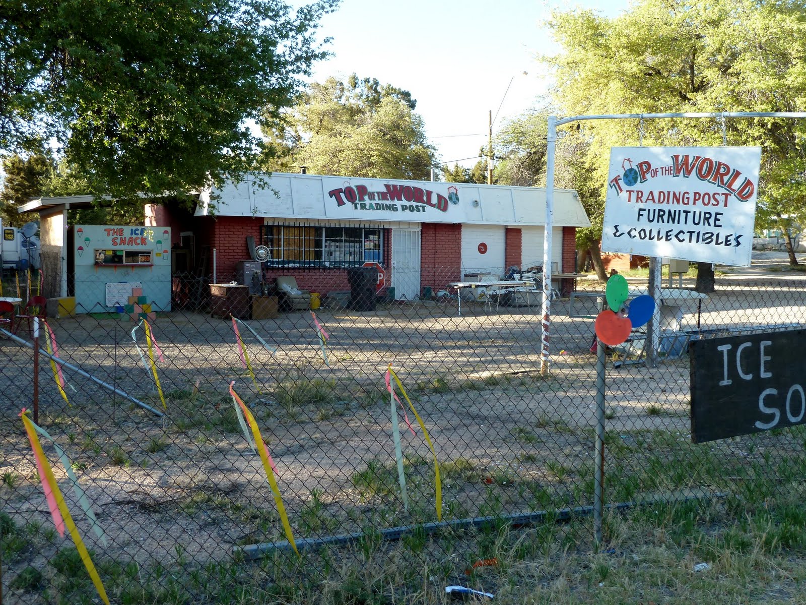 This is Charlie's Place at THE TOP OF THE WORLD. Charlie is a friend of Toni, who arranged that SPIA spend the night parked in front of his building...where it now is.
Perhaps I can get a photograph of Charlie in the morning for tomorrow's Blog.
I know, Kram...you want another pic of Toni right here...NOPE
DAILY REPORT: Made 4 legs today: Leg 1 - 20 miles early this morning.
DAILY REPORT: Made 4 legs today: Leg 1 - 20 miles early this morning.
Leg 2: 6 miles back on Hwy 60 after reaching SUPERIOR; Leg 3: 6 miles to the Tunnel;
Leg 4: another 6 miles back down the Canyon on Hwy 60 from TOP OR THE WORLD.
I AM POOPED !!! = 38 miles...much of it up steep hills.
SEE YOUR IMPACT.ORG.: Credit 38 miles @ $0.02 per mile = $0.76 for the day
In the morning, will walk East on Hwy 60 to the small town of MIAMI - about 8 miles - and on to the intersection with Highway 70...another 8 miles or so...then South on Hwy 70 through Sonny's Apache Reservation, and on to EL PASO, TEXAS.
1 comment:
Hi Bruce-
We are still checking in with your progress and are so very pleased with how far you have gone and so very pleased that you have warmer weather! Stay well.
Barbee, Larry and Sailor
Post a Comment