
 UMPQUA RIVER LIGHT HOUSE, REEDSPORT, OREGON
 REEDSPORT, OREGON
 SKUNK CABBAGES - MUST BE ANOTHER NAME, BUT AS A KID, WE CALLED THEM SKUNK CABBAGES ! THEY DO HAVE A SKUNK-LIKE AROMA
 SKUNK CABBAGE BULB
 SKUNK CABBAGE - THE COMPLETE PLANT...QUITE BEAUTIFUL
 UMPQUA RIVER ENTRANCE...NOTE BREAKWATERS ON BOTH SIDES OF THE CHANNEL
 CLEAR LAKE...EXCEPT FOR THE BRANCHES IN THE FOREGROUND...
THIS ENTIRE PHOTOGRAPH SHOWS THE LAKE BOTTOM THROUGH THE WATER
 PLEASE CLICK ON THIS PHOTO.
  HOME MADE SAND DUNE BUGGY
 SAND DUNE...THIS IS A VERY HIGH ELEVATION...AND FAR INLAND FROM THE PACIFIC OCEAN.
 LAKESIDE, OREGON IS A SMALL VILLAGE MID WAY BETWEEN REEDSPORT AND COOS BAY, OREGON
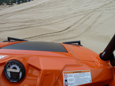
 THE DASHBOARD OF THE DUNE BUGGY I RODE IN
 ENTERING THE SAND DUNE PLAYGROUND...IT IS ON US GOVERNMENT PROPERTY AND IS MAINTAINED BY UNCLE SAM.
 CLICK CLICK, PLEASE...THIS IS THE PLAYGROUD
 SAND DUNES FOREVER...CONTINUE NORTH AND SOUTH MANY MILES
 GETTING READY TO CLIMB A 75 DEGREE SLOPE UP TO ME
 GOING DOWN...NOTE THE DEEP TIRE TREAD DESIGN...NEEDED TO GET A GRIP ON THE SAND
 IT IS A LOT STEEPER THAN IT LOOKS...MUST WORK ON THAT PERCEPTION
 I WAS ALLOWED TO SIT IN THE DRIVER'S SEAT...NOT ALLOWED TO DRIVE, THOUGH
 PLEASE CLICK ON THIS PHOTO.
IT IS AN OLD TREE STUMP WITH MOSS GROWING ON IT...
BUT, LOOK AT ALL THE MINIATURES BLOSSOMS...NEVER SEEN SUCH BEFORE
 HOME MADE SAND DUNE BUGGY
 SAND DUNE...THIS IS A VERY HIGH ELEVATION...AND FAR INLAND FROM THE PACIFIC OCEAN.
 LAKESIDE, OREGON IS A SMALL VILLAGE MID WAY BETWEEN REEDSPORT AND COOS BAY, OREGON
 THE DASHBOARD OF THE DUNE BUGGY I RODE IN
 ENTERING THE SAND DUNE PLAYGROUND...IT IS ON US GOVERNMENT PROPERTY AND IS MAINTAINED BY UNCLE SAM.
 CLICK CLICK, PLEASE...THIS IS THE PLAYGROUD
 SAND DUNES FOREVER...CONTINUE NORTH AND SOUTH MANY MILES
 GETTING READY TO CLIMB A 75 DEGREE SLOPE UP TO ME
 GOING DOWN...NOTE THE DEEP TIRE TREAD DESIGN...NEEDED TO GET A GRIP ON THE SAND
 IT IS A LOT STEEPER THAN IT LOOKS...MUST WORK ON THAT PERCEPTION
 I WAS ALLOWED TO SIT IN THE DRIVER'S SEAT...NOT ALLOWED TO DRIVE, THOUGH
THIS IS A VERY HIGH TECH DUNE BUGGY...PRICE ABOUT $15,000.00
 PANORAMA
 STARTING DOWN...IS NEARLY VERTICAL...PHOTO IS DIFFICULT TO SHOW THAT...AND WE WERE MOVING QUITE QUICKLY...TRYING TO HOLD ON AND GET A STEADY PIC.
 GROUP OF ATV'S RENTED FROM CHRIS...$1.00 PER MINUTE...MINIMUM 30 MINUTES. THAT IS THE LEAST EXPENSIVE MACHINE...PRICE GOES UP TO $120.00 FOR 30 MINUTES FOR THE MORE SOPHISTICATED MACHINES.
 NOW, THAT A BIT BETTER SHOT...FALLING NEARLY STRAIGHT DOWN OFF THE SAND DUNE...QUITE EXCITING
H HEADING FOR HOME
 SPIA AND "OUR" HIGH-TECH BUGGY
 BILL IS WEARING A "CHEST PROTECTOR"...SAME AS WORN BY DIRT BIKE RACERS
 HEADING FOR HOME
 SPIA AND "OUR" HIGH-TECH BUGGY
 BILL IS WEARING A "CHEST PROTECTOR"...SAME AS WORN BY DIRT BIKE RACERS
SUCH SAFETY EQUIPMENT IS NOT REQUIRED, BUT SOME WEAR THEM AS THE DRIVERS SOMETIMES FALL OFF THE ATV.
 SPIN REEL OFFICE
 AN ATV DUNE BUGGY
 AWAITING NEXT SESSION...MANY FOLKS ARE JUST TO THE LEFT TAKING A BREAK WITH ICE CREAM OR A DRINK
 THE SIGN
 VERY DIFFICULT TERRAIN...LOOKS LIKE "EXPERT" TERRITORY
 SPIN REEL OFFICE
 AN ATV DUNE BUGGY
 AWAITING NEXT SESSION...MANY FOLKS ARE JUST TO THE LEFT TAKING A BREAK WITH ICE CREAM OR A DRINK
 THE SIGN
 VERY DIFFICULT TERRAIN...LOOKS LIKE "EXPERT" TERRITORY
DAY 37 - REEDSPORT – SAND DUNES
Sliding from under my soft warm Duvet’s, I was not anticipating a very interesting day…22 miles of hills and off-beat US 101…and there was no HOT water in the shower, so used hot water on a wash cloth and did my best…we are definitely spoiled…200 years ago, a plunge into the icy creek did the job...then a snuggle under a handy Bear Skin…
But, I did survive rising into my new day. Unplugged SPIA’s electrical power and drove down the hill to the Umpqua Light House for a few photos. A non-event really, as the Light House sits behind high fences with “KEEP OUT” signs…it is US Government Property – actually US Coast Guard, for whom I have he highest regard and respect.
Then drove SPIA back to Reedsport, Oregon to fill SPIA gas tank. Parked and walked the 4 miles back to the Light House Road leading off US 101…and return to SPIA.
It was 8:00 am before I started walking today. For the next 6.5 hours, I moved SPIA 5 times and walked for a good 6 hours doubling the miles needed to go South. As I mentioned, was not expecting too much from today’s walk…not much to photograph…modest hills…until arriving at a SpinReel Campground and Sand Dune Recreational Area.
Figured…Why Not? So I pulled into the SpinReel Dune Buggy and ATV Rental…and am so glad I did. Introduced myself to Chris, the Manager. Told him about SAM & ME and that I would like to tell his story on my blog…
Chris took time from his busy schedule…dozens of clients were renting his ATVs and riding the Dunes…but he took time for me. He told me how the Sand Dunes came to be and why there are where they are and why they continue to grow.
One must mentally picture the HUMBOLT CURRENT and the JAPANESE CURRENT of the Pacific Ocean. Because of the Earth’s Rotation, these two currents rotate WEST along the Equator from Central America to Asia, then split North and South to flow in a circle…Humboldt going South along Antarctica and East to South America and North, returning to the Equator. The Japanese Current takes the Northern Pacific route, flowing North along Japan and Siberia, East along Alaska, and South along North America, returning to the Equator.
OK…got that…two big concentric circles of ocean current.
Oregon’s Sand Dunes are concerned with the Northern Circle…the Japanese Current.
AND THE COLUMBIA RIVER…
The Columbia River, joining the Pacific Ocean at Astoria, Oregon, 200 miles North of the Oregon Sand Dunes, is the primary source for all the Sand Dunes. Draining nearly all of the Northwest Continental North America, the Columbia River brings something like 936,000 cubic meters of silt to the Pacific Ocean each (sorry, don’t remember if it is a Day, a Month, or a Year)…anyway it’s a lot of silt. That silt is picked up by the Japanese Current and during the Summer months carries it South until it hits the Oregon Coast a bit North of Cape Anago and then Cape Blanco…the two most Westerly points of land in North America.
Concurrently, the Pineapple Express – South West winds coming East across the Pacific Ocean from Hawaii, pushes the sea water into Capes Anago and Blanco, where it deposits the Columbia River silt on Oregon’s Beaches.
NEXT, in the winter months, the Pacific Ocean Winds shift away from Hawaii and instead come from Siberia area…or from the North West. This wind pushes the Summer silt inland and raises it into massive DUNES…some as high as small mountains.
Next year, the cycle continues…a never ending supply of silt for Oregon’s Sand Dunes.
Kinda interesting, huh?
Surprise of the day: Chris asks me to be his guest for a ride in one of his supped up Dune Buggies up onto the Sand Dune Playground. Did I refuse? Does the Pope have …never mind…I did accept and had the ride of my life. Tried to take photographs during my ride…quite impossible to catch the steepness of the hills – at least 75 degrees – we climbed and dropped off of.
I was expecting a bumpy jarring ride…that new machine has suspension, according to my driver (I did NOT drive), Christian, that is the same as the new high-tech race cars…The entire ride was like sitting on a comfy Recliner…now on your back…now about to fall out forward as we zoom almost straight DOWN.
Thank You…Thank You…Thank You, Chris and Christian.
Drove SPIA back out to US 101 and for the next two hours, walked and walked and walked…Came to a Coos County Campground and turned in. Checked for Verizon Signal Strength…5 bars…and decided to stay the night.
Had a lengthy chat with the Campground Host, David and the Campground Park Ranger, Brian…bottom line is I pay the Bicycle Rate – because I am a walker…and share my good fortunes with so many readers…that’s YOU, folks.
Actually, my Social Security $$ don’t go so far as to allow SPIA to check into Campgrounds very often– where we have electricity for the Mini -, so have decided to ask for a “Senior” discount or consideration for our efforts to bring our World to YOU.
So far, so Good.
DAILY UPDATE: Walked double from Reedsport to 6 miles shy of Coos Bay = 30 miles…count 15 miles
SEE YOUR IMPACT.ORG: Credit 15 miles @ $0.02 per mile = $0.30 for the day.
Tomorrow will walk into COOS BAY, OREGON and back to SPIA, still parked at the Campground. Then we will head South through Coos Bay and pick up our routine on a 51-mile stretch of wilderness towards BRANDON, OREGON.
There are NO campgrounds on that stretch, so we will be on our own for the next 2 – 3 days…hope we have Verizon Signal along the way…if not, blog updates may be delayed a bit.
No comments:
Post a Comment