* * * * * * * * * *
We have finally achieved a degree of success in moving forward with our blog.
It is now 2:30 am, May 17, 2013. Have just completed loading images into our Google blog for our walk completed on May 14...from LOW MOOR, Virginia to LEWISBURG, West Virginia.
As fate would have it, we have been forced to stop for the night(s) in places where no electrical power was available...or the VERIZON signal was so weak...that our minii-computer could not process photographs.
Only May 14 has been completed. We have yet to upload May 15 and May 16 images...which must wait until we walk a bit further West from our current location at HAWKS NEST STATE PARK, West Virginia. We will be leaving HAWKS NEST at daylight - assuming we have daylight, for at the moment the residue of the spectacular thunder / lightning storm at sundown last evening...i.e., DENSE FOG, enshrouds the green hills of West Virginia. It will be quite dangerous for SAM and ME to venture out onto the already trecherous highway US 60 which leads up and over the remaining 8% 5-mile long mountain lying in wait between HAWKS NEST and CHARLESTON, West Virginia.
In addition to a hand full of homes, LOW MOOR consists of the above PENNY'S DINER and the OAK TREE INN MOTEL next door. SAM and ME have taken a room at the Oak Tree Inn for the night, while enjoying another of Penny's Diners (there are a half dozen or so such Penny's Dinver across the USA...some of which I have previously enjoyed during our walk).
Please say HELLO to (l.) TAMMY and DOODLES, both of whom work at the Diner and Motel. Tammy offfered me her home on our next walk through LOW MOOR. Tempting, I must say, to stay on another night - or so!
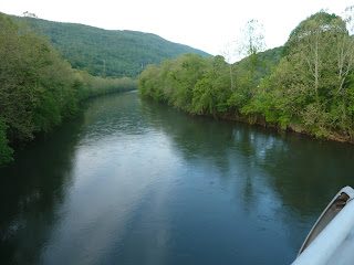
The state of Virginia is increasingly mountainous as we walk US 60 to nearby West Virginia. From among the hundreds of forrested green mountains rising to the West, many rivers and streams flow toward Chesapeake Bay some 150 miles behind us.
I-64 (Interstate 64) is more or less paralleled by Old Route 60. We are not allowed to walk I-64, so we must cross the waiting West Virginia mountains on the narrow - no berms - US 60...with it's broken asphalt roadway travelled by many 18-wheeler logging trucks...vehicles which tear up the edges of the pavement and hog the meagre berms as they round the sharp curves...a constant challenge to SAM and ME as we keep CONSTANT vigil...look away for even a second or two results on a monster truck baring down on us...us, with no place to hide...or even get out of the truck's way.
EXCITING TO SAY THE LEAST.
I have one advantage...since driving those 18-wheelers from age 9 (yes, first solo at the wheel of an 18-wheeler was at age nine), I have a rather good understanding of the mind-set of truck drivers...I am for ever inside the driver's head as he first sees SAM and ME walking ON THE PAVEMENT directly into his path (we must walk on the pavement, as there is NO side berm for us to walk). So far, the driver(s) and I have communicated a safe passage past each other. As we walk rather slow, we meet the same trucks / drivers many times, so they know we are out there...and keep on the lookout for us...often with a few blasts on their air-horns in greeting. They somehow recognize that I am a dependable "driver" of SAM and respect me as I do them.
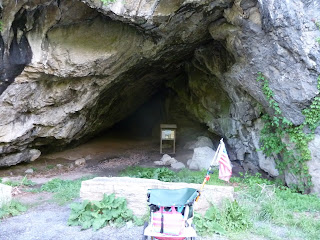
US 60 passes by many natural rock caves...some reaching directly onto the roadway.
Reaching COVINGTON, Virginia...a steep hilly dominated old and busy small city, I was at once surprised...then content...to find a number of motels with plenty of rooms available for rent. Stopping in LOW MOOR, we were informed that we MUST stay in Low Moor because there was considerable new factory construction going on in Covington, making it impossible to find a place to stay. ...then content, because we would not have met Tammy or Doodles if we had continued on to Covington last night.
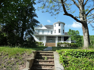
Covington home.
Beyond Covington, the big steep hills await. Note the lack of side berms...the white line rests against the guard rails...and against the vertical cliffs...no place for SAM and ME to get out of the way of passing vehicles...so, what, you ask, do we do:
SAM and ME "STOP" until we see the vehicles see us (I ALWAYS wear WHITE gloves and vigorously WAVE to every passing motorist...just to be certain they see us)...then we slowly continue our walking and rolling...the vehicles themselves STOPPING for us to find a spot to move off the pavement.
Working cautiously and together, we have all avoided any confrontation.
Please say HELLO to (CLINTON and MONROE).
At a point some 10 miles East of WHITE SULPHUR SPRINGS, Old Highway 60 combines with I-64. It is not allowed that pedestrians (even with carts) walk on the Interstate roadway. The only option is to walk an additional nearly 50 miles on narrow backroads through increasingly difficult mountain roadways...or hitch a ride.
Clinton and Monroe agreed (after I twisted their arm with a 20-dollar bill) to carry SAM and ME in the back of their pickup truck the 10 miles over I-64 to the small town of White Sulphur Springs.
Front yard Wind Mill.
White Sulphur Springs main street...aka US 60.
What I have NOT shared on the trip (please see last year's walk through White Sulphur Springs for details of the GREENBRIAR GOLF COURSE properties ... the primary objective of many who visit White Sulphur Springs).
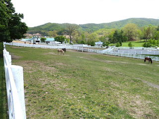
A beautifully appointed horse ranch on the West outskirts of the town proper. To the West lies the many world renouned golf courses and hotels...which I have not visited this trip.
A tiny property adjacent to US 60 a bit West of town.
Editorial Note: The VERIZON service signal here at HAWKS NEST is so bad that I am having a difficult time keeping the signal turned onto my computer...each sentence is interruped with signal drop-out, endangering of losing any "unsaved" material...more than once, I have forgotton to "save", which means I must re-create all that is lost.
A very tedious and tiresome task, as it is still in the wee hours of the night and I really should be sleeping. Spend ALL DAY trying to process photographs for this blog update, succeeding in completing only 12 (yes, twelve) images.
I think I deserve a raise...what is 50% of ZERO $$ ?
After climbing up and back down three short 8% mountains, we have reached the rather beautiful and historic town of LEWISBURG...where we intend to stay the night.
Alas, there are no rooms available on US 60...plenty of rooms if we head North on Route 63 to the intersection with I-64...much out of out way. So, we continue West on US 60 into the evening setting sun...finger crossed that we find a place to get out from under the black rain clouds that are moving our way.
Downtown Lewisburg.
Tribute to the local hero...the Confederate Soldier.
Please say HELLO to Eddie. Eddie is busy tearing apart his asphalt paving machine.
Met Eddie and his crew-mates of a dozen or so WEST VIRGINIA PAVING company, who parked their 8 large pieces of paving equipment at the old abandoned gas station about one mile West of Lewisburg.
SAM and ME stopped...appraising the tiny roof hanging over the old gas pumps...the available space taken up by the massive paving machines.
A small plastic bench rested under the roof and against the building wall...the perfect place, I say to Eddie, for my sleeping bag tonight.
Please say HELLO to DENNIS and PAUL...two of Eddie's colleagues. Paul took me under his wing...offering me food and drink, as I joined Eddie - by holding my flashlight as Eddie labored in the dark recesses of his paving machine to find the reason for one of the four (4) asphalt HEATERS (needed to keep the mix hot during the paving process) not heating properly. I worked with Eddie well past sunset...with no resolution of the heating problem.
In the morning, after spending a comfy sleep in below freezing temperatures, I had packed SAM up when the crew returned at 6:30 am. Paul again to my rescue, hands me "breakfast" and hot coffee...breakfast being four huge biscuits smothered in yummy gravy.
The guys - and a couple gals - were all a__ holes and elbows as they cranked up the diesel engines of their massive beasts...visiting hours over...a full day of hot dirty work waiting for the West Virginia Paving crew...
and some more mountains to climb for SAM and ME.
It is now 6:30 in the dense foggy morning at the HAWKS NEST on May 17, 2013. It has taken all yesterday and from 2:30 to 6:30 last night / this morning, to create this blog update...
I am sleepy, hungry, and not pleased to pack up SAM and head out onto US 60...with only a few yards visibility in the thick fog.
Perhaps I will go fetch a bite in Steve's magnificant Lodge Kitchen (details later), return to my impeccable room with a vista of miles over the tops of steaming green hills, slip back under the feathers and sleep a few more hours...perhaps 'til 11:00 am checkout.
Today, we have only about 15 miles to walk and roll to the delightful small village of GLEN FERRIS, where we intend to take a room in the magnificant historic hotel on the banks of fabled NEW RIVER.
...only one 8% 5-mile mountain stands between HAWKS NEST and GLEN FERRIS...
...should be a nice easy afternoon stroll for SAM and ME.


1 comment:
Be careful out there, Bruce!
Post a Comment