
Having seen many of the World famous coast lines, chose the Oregon Coast to be among the finest.
After driving the California Route 1, must give California some serious consideration. One thing is for certain ... the land comprises mostly CLIFFS dropping vertical hundreds of feet directly into the Pacific Ocean.
Route 1 is a challenging roadway. Nearly 1,000 miles of switchbacks clinging impossibly to near shear drops into the sea. Not a route for the feint of heart ...
Have stayed last night in the city of GUALALA, California and driven to near the city of EURICA, California. Early tomorrow morning, will cross from California into the State Of OREGON.

Pacific Ocean Fronting the City of GUALALA, where we stayed last night.


Wind shapes the seaside trees into permanent stretched out plants.

Arriving in the MEGA-CITY SAN FRANCISCO, California.
The City has extended Route 1 into I-280 and across the City proper, arriving at the entrance to the GOLDEN GATE BRIDGE.
Living in MARIN COUNTY three different times, GG BRIDGE was an almost daily event.

This city street is pressed into service to speed cross-town traffic.

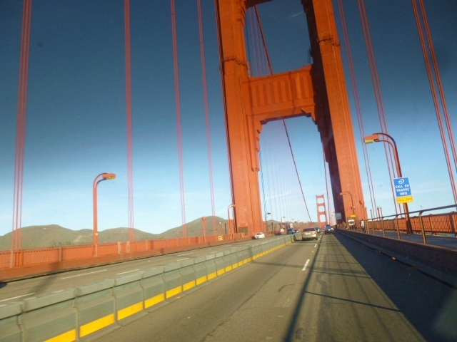
Too close to photograph the entire TOWER in one image.
Imagine the two images stitched together ...not bad from a moving vehicle ... Yes I know, promised to no longer do that. Being ALONE, I must shoot on the move ... or very few fruits for my labor.

Looking from the MARIN COUNTY GG BRIDGE Parking Lot.

Viewed from the GG BRIDGE Parking Lot = BAY BRIDGE in the far distance.

From the same spot, another image - into the SUN - of the City of SAN FRANCISCO.

Ocean Water in San Francisco Bay has flooded about 1/4 square Mile.

Route 1 continuing from the Golden Gate Bridge up the Pacific Ocean Coast.

Looking closely to see private homes clinging to Mt. "TAM" foot hills.
I did drive to the top only to discover trees growth has blocked most of the view. Trails on and about the top are available for those in good health for walking trails.

From the TOP of Mt. " TAM ", distant San Francisco HILLS can be seen.

Driving down the North West Mt. TAMALPIAS roadway, we look down on STINSON BEACH.

Behind the Sandy Beach is an estuary of a small river which cuts through the "SPIT" on which STINSON BEACH village sits.

Having driven around the Salt / Fresh water estuary, we come to the quickly flowing river as it reaches the Pacific Ocean.

A few degrees turning to the right from the spot of the above picture, continues the beach of the Pacific Ocean.


Please say HELLO to RICHARD "Willy" of SPOKANE, Washington.
Willy drives a TOYOTO, spit'n image of SPIA # 1 'round and about America. At 57 years old, he has that which for me is growing short ... TIME.

Please say HELLO to JOHN, local businessman and ARTIST.

JOHN's Surf board TOTEM POLE.

Town of BOLINAS by-the-sea.


GUALALA, where we stayed last night.

FORT BRAGG, the largest city on the Northern PACIFIC COAST.

Another day is coming to an end...
* * * * * * * * * *
MERRY CHRISTMAS !!!
... from the tiny village of RIO DELL, near the North Entrance of the world famous AVENUE OF THE GIANTS .... Very worth while drive to see the Giant Red Wood Trees.
...we have been asked to create our blog update in the - The Joint Is Jumping -
RIO DELL PIZZA FACTORY.
Had SNOW FLAKES mixed in the incessant rain which is still coming down.
SNOW is in the air tonight down here in California PACIFIC OCEAN foothills.
Tomorrow, we shall see !
No comments:
Post a Comment